
Pro všechny CTXkáře skvělý článek :)
xChange2 - collection sorting, export and GoogleEarth
Categories: Minelab – tests and reviews , Minelab CTX 3030 metal detector
If you are one of the meticulous ones, using xChange2 to record your findings. You may find it useful to use a simple application to sort collections in xChange2, export to KML and KMZ including FindPoints and photos. KML and KMZ files can be opened directly in Google Earth, but many other applications can be used.
Sorting collections
In xChange2 you can create collections that can store not only finds, but also routes, settings, etc. This can make your records a bit more organized. However, the application does not allow you to specify the order of the collections. It's a small thing, but as a pedant, it frankly annoys me to have my collections folders scattered around in the order I created them without the ability to change it. I want to have the "Waste" collection at the very bottom of the list and the "Routes" collection at the top!
So I created a simple program that allows you to sort the collections according to your own needs.
The program does not need to be installed. Download the zip and unzip it to your desktop. Using it is easy - when opened, the program will load all the collections you have in xChange2. Drag the rows up or down to sort the contents according to your needs. Then you just click the "Save" button, start xChange2 again and you're done.
If the program fails to find the xChange2 installation on your disk, you will have to "show" it by dragging the xChange2 shortcut from the desktop to the program window. That's all.
Export to KML, KMZ
Over time, I started using GoogleEarth for archiving routes and finds. Although the application has its limitations, it is still very useful. So the question is - how to get GeoHunts and FindPoints into KML or KMZ for GoogleEarth? Simple!
My app will do everything for you. Click on the tab "GeoHuntexport" or " Collection export". Here you will see a listing of all GeoHunts or collections you have in xChange2. Highlight what you want to export and click the export button with the desired file type.
GeoHunt export - does exactly what you would expect - it exports the route of the selected GeoHunt, adds all FindPoints and if you select the KMZ file, it also adds photos of each find.
Collection export - if you sort your finds into collections along the lines of "Coins", "Statues" etc. the program will export all the findpoints you have in the category.
In case you don't have individual collections by find type, but by location - i.e. for example the collection "South field behind the village" etc. and you have all the FindPoints in a given location including GeoHunts in the collection - the application takes this into account and creates a single file with all the routes with the FindPoints/Finds including photos (KMZ )
*.KML - exports only the route , findpoints with name,description, date andfind type WITHOUT PHOTOS
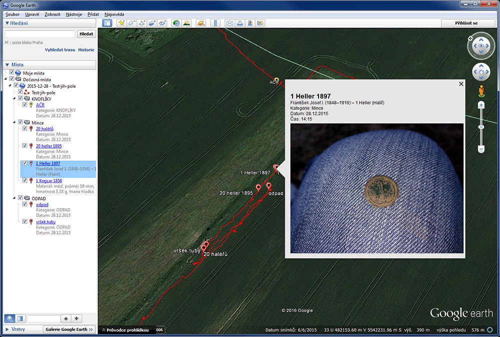
*.KMZ - exports everything as KML, but in addition adds to the findpoints all the photos you have stored for the find in xChange2.
By default the photos are packed in full resolution - as you have them saved - so KMZ files can be very large. However, this can be changed in the Export Preferences.
FindPoints remember the collection from xChange and are color coded by collection - so if you have coins sorted in the "Coins" collection they will show up in a separate "Coins" entry/folder in GoogleEarth. This is a big advantage - you can turn off the types of finds you don't want to see on the map in GoogleEarth . Alternatively, you can hide entire routes and keep only the points showing the finds.
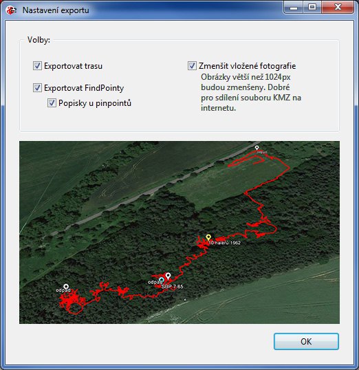
In theexport preferences you can set additional options for the content of KMZ/KML files:
- you can choose whether you want to export only the route or only the FindPoints, or you can enable the legend for the pins on the map.
- In case you want to send a KMZ file with your photos to someone by email - you may be bothered by a too large file. In fact, the included original photos can be tens of MB. You can choose to automatically shrink your photos by checking that option. It takes much longer to export. All photos larger than 1024 px will be resized to the maximum size: 1024x1024 px. Your original photos will of course remain unchanged in xChange.
Info for Google Earth users on OS X - if you don't see photos from KMZ files, it's supposedly a Google Earth bug. It doesn't read file paths properly on OS X. Try updating the app, it should be fixed in the new version. You can also try checking the "Allow access to local files and personal data" option in the Tools->Options->General preferences.
Development
The application was created as a one-off for your own use, some bugs are not addressed and its use is therefore without warranty. Back up your data. I have no problem to extend the program further according to your possible suggestions and ideas. Are you interested in importing it into xChange2? Bulk exports? Exporting reports to PDF? Let me know :o)
xChange2
Some simple xChange2 shortcuts for those who don't know:
- Ctr+ and Ctrl- enlarge and reduce graphics and fonts in the window
- F11 - full screen mode
- F12 - launch the console, for those who want to customize the look of the application by editing the source css
Links
My app is available for download here: http://www.wlk.cz/xchange2-extend.zip
GoogleEarth free download here: http: //www.google.cz/intl/cs/earth/download/ge/agree.html
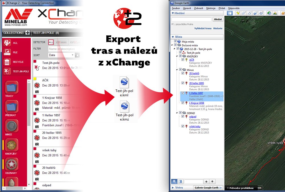
Exporting findings from xChange has never been easier...
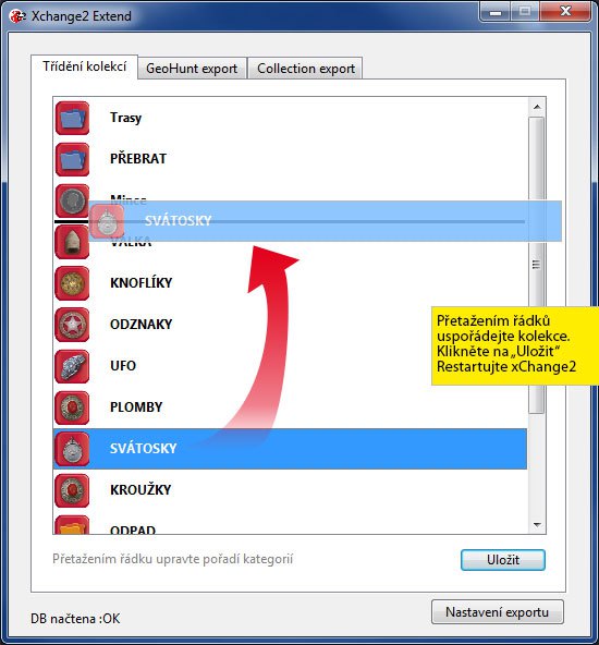
Custom sorting of collections
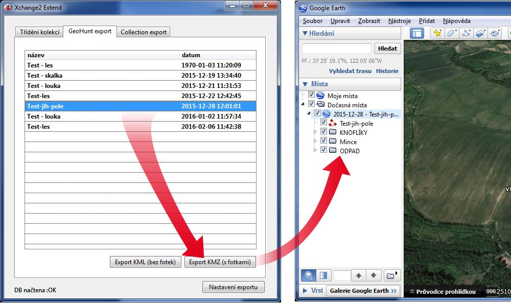
FindPoint collections are preserved when exporting GeoHunts
The app will add or reduce the size of the finding photos
Export preferences to KMZ and KML
The article is included in categories:
- Archive of articles > Metal Detectors - Reviews and Tests > Minelab – tests and reviews
- Archive of articles > Metal Detectors - Reviews and Tests > Minelab – tests and reviews > Minelab CTX 3030 metal detector
Post


Super článek k užitečné věci. Neni i něco podobného pro andoid? 

Jestli máš namysli aplikaci pro trasování a ukládání nálezů pro Android, pak můžu doporučit THS - https://play.google.com/store/apps/details?id=com.meshsoft.ths
Ja nutné nejprve pochopit základní principy práce s programem, ale když se do toho dostaneš je to bezkonkurenční nástroj. Umožňuje také exportovat KML trasy do jiných programů a při propojení s Dropboxem ukládá k exportovaným trasám i fotky, a navíc - je v češtině!
Důležitá je jedna věc - hned po instalaci si nastavit v předvolbách Obnovovací vzdálenost na hodnotu "0", jinak jsou ukládané trasy hodně nepřesné! Plná verze stojí pár kaček. Vyplatí se. Autor navíc přislíbil v dohledné době další vylepšení pro práci s uloženými nálezy.


A něco česky by nebylo??? 
V tom případě doporučuju tohle: http://www.easytoys.cz/detektor-kovu-detsky-TP16469.html a tohle: http://windows.microsoft.com/cs-cz/windows7/getting-started-with-paint

This is great 
Thank you
Díky moc, a ted hedna blbější otázka. Nežere to hodně dat? (Mysleno připojení)
Přiznám se že jistě to nevím, ale Google Earth žere podle mě maličko víc než xChange2. Myslím že je to ale zenadbatelný rozdíl. Jsou to podobné balíky mapových podkladů.
Kdybych měl k PC třeba mobilní připojení s datovým balíčkem 1.5GB, tak nepoužívám ani jedno, ani druhé. To si raději budu šetřit data pro příjem e-mailů. Navíc stačí pár větších aktualizací ve Windows a datový limit je hned vyčerpán :(