Pěkně napsaný a užitečný článek ...moc pěkné
Where the village was originally farmed
Categories: Maps and GPS
When we search the landscape, we are often faced with a question that is crucial to our further search. Was there anything here at all? Is it fair to say that there always has been?Archaeologists themselves have attempted to answer this question in some general way, defining the terms "something" and "nothing" as follows. The rest is a potential "something" in terms of the history of man and his footprints. Well, we're standing somewhere on the edge of the present forest, and we're observing the roll field. I wonder where the roll fields were 500 years ago? Or a thousand years ago? If we're tempted by the discovery of ancient coins, it would be good to know, wouldn't it?
We're concentrating on the villages. First, we need to accept the information that about two-thirds of the old settlements, small and large, have disappeared. We can't rely on written records. Where is it written that what is written is given when almost nothing of the written records have survived. Remember how difficult it is to find the owner of a stamp in the chronicles, because you will learn at the village hall that the chronicle was somehow lost, after the war... So unwritten history and observations will contain more information than mere lines on papers.
Observations from the edge of the forest can show landforms such as various plateaus, faults, and perhaps rectangular crossings of roads. Old roads. Remember how many times you stood somewhere in between and wondered... where the hell was that...? But we're not high enough to see everything from a bird's eye view, so yay for maps.
Thefirst example is a typical medieval village. A model, to give us an idea of what we're after. The villages were basically simply arranged, either in layman's terms "dokulata" or "nadloulou". A dokulata village has a regular cadastre. It was in the middle of a cleared area. There must have been water somewhere around it, and there must be now. It is the lack of water that is one of the reasons for the village's disappearance and relocation.
Example of a dokulata village - current state.
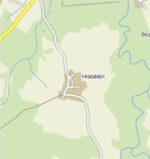 |
How was such a village arranged? Even now, on the primitive map above, you can see the right angle of the roads. The fields were laid out so that you could drive right out of the yard, ideally. This means that the recognised layout of the fields also answers the question of where the merchant's road was not
The cut is from www.cuzk.cz land registry.
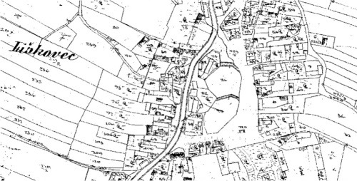 |
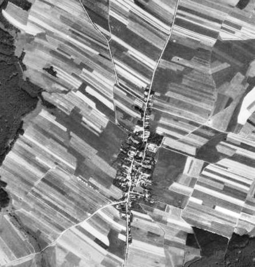
Maps from the Joseph and Theresienstadt land registers or aerial photographs from before collectivisation was completed would give an even better overview. We only have that picture... .
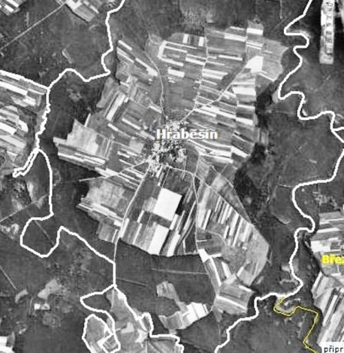 |
You can't miss a village like this on a map. And there is a lesson here. It had a fairly regular cadastre. That means the suspects will be what? Yes, that's right, irregular cadastres in an otherwise clear landscape. Variously elongated, joined, polygonal, or stream-like where the village is off-centre.
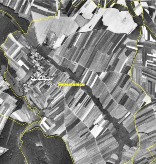 |
A village off-centre in an otherwise fairly regular cadastral landform. Certainly the terrain may play a role, but the question is whether the fields in the north-east corner more than a kilometre from the village would be truly uninhabited. But check this out for yourself... in your own villages. You will certainly find even stranger cadastres when studying maps in the relative plain, where settlements are absent (in the centre) according to the "dokulata" theory. If nothing else, it's great fun, preparation for the hunt... So why did the villages disappear?
They disappeared because they were destroyed by war, disease, change of feudal lords, loss of protection... The destruction is described in the literature as "villa desolata". The abandonment of the village, the "villa deserta", occurred after it was relocated due to drought, floods, by the decision of the upper class.... Or after extinction following illness. The causes are many over the centuries. More than reasons to stay.... Again, the old names on maps, the various Lhota in the cadastres, Modletiny, places ending in ..ice, ičiny... It takes imagination, and reading. Lhotec Forest. On Burnt. Behind the cottages. And there's nothing around that looks like a settlement. Isn't that suspicious? Of course, be careful, check the monuments list to make sure you're not hunting on a manor, a site on the Central List of Archaeological Sites. If you do find your outlandish site there, leave it to the emperor's... If the village is not classifiable as "dokulata", it can be lumped into the "overlong" box. That is, the cottages were along the road, we have no proper centre, and the typical rectangular crossing or remnant of it may be missing. It may not just be some really upland, rock-cut settlement. The edges of the fields are often made of stone, sometimes there are elongated mounds of picked stones in the middle of the fields. Long stacked stones may have been easier for farmers to work around than round piles, who knows. When they were shovelling with the plough they stacked the stones in contours, creating a kind of terrace. You must have seen them a thousand times, and wondered if there were orchards or vineyards. Fields they were.
 |
The edges with the stones are slightly highlighted with a faint red line. A village "overlong" surrounded by land like spokes around - a plain by the way of cultivation - is typical of various highlands, hills, undulating landscapes. If you can find a place where stone ramparts run either side of the centre line, you at least have a road. But beware of confusion with stacked forest boundaries... but at least there was a path there too. Some things are still recognisable, some are not. Studying the evidence can improve the chances for any searcher, but it's not everything. Luck plays a part, and so does the amount of mileage. Both events, luck and the amount of scanned area, will affect what you end up with under the coil. One final note. It's about a coin with a hole in it. If you find a coin with a hole, one that looks like a nail, in a field, in the woods, it may mean that ... ... that you have a location somewhere around you where people used to gather. It shouldn't be the case that you just find one and nothing else. Coins that were expiring, which was the norm when silver coins were minted as a race in the Middle Ages, were nailed to a post. So that everybody knows what's worthless...
litrfree
Want to find some historical treasure too? Check out our metal detectors.
The article is included in categories:
Post
Zajímavé!
Ano! Pěkně napsané. Rád si přečtu úvahy jiných. Díky za tu práci. 
Díky Tvému článku věřím, že se posunu kupředu při hledání mincí. Díky.
 hodně zajímavé, jednu probodnutou minci mám 3 krejcar
No super, zajímavé úvahy. Něco na tom je ! 

No asi budu vypadat jako kverulant. Katastrální mapy a snímkování z 50. let je hodně zajímavou pomůckou, ale hledání starých zaniklých vesnic podle těchto "nepravidelných katastrů" je nesmysl. Přesněji řečeno lze z nich poznat jen vesnice zaniklé po odsunu Němců. Obce, které padly za oběť například 30leté války, však už ne.
Ty "nepravidelné a pravidelné katastry" na leteckých snímcích jsou pouze zemědělské hony (jakési záhony) a se skutečnou hranicí pozemku většinou nemají nic společného - jen ukazují jaké všechny plodiny zemědělec na svém políčku pěstoval. A ono jedno políčko se zase klidně může skládat z několika parcel (a ve finále každá může patřit úplně někomu jinému).
Katastrální mapy jsou až výplodem nejrůznějších pozemkových reforem. Například otisk Stabilního katastru FJ-I o předbělohorské době nevypovídá prakticky nic.
Jinak, té vesnici "dokulata" se říká návesní (náves v centru - baráky okolo). Typická je pro českou rovinatou krajinu. Ta "nadlouho" je lánová nebo též komunikační a je charakteristická pro hornatou krajinu Sudet - zpravidla kopíruje potok a s ním souběžnou cestu.
to witt: Linearita historického evoluátu je kostrou katastrálního vývoje, včetně excesních epizod. Gemorfologie může mít významný vliv, to sedí. Novověká kartografie navazuje na středověká popisná mapování, i když jen z části, protože víc se toho nezachovalo než zachovalo. A Sudety jsou hornatým rázem specifické.  Komparativně lze uvést místo identifikátoru "lánová" též ekvivalent plužina, kterému jsem se snažil vyhnout. Technické pojmosloví považuju za vhodné eliminovat, neboť slouží k potlačení objevností možných vertikálních diskusí. Technikálie v podstatě maskují nedostatečnou odolnost nositele názorů ke konfrontacím se širším gnosticismem. K strohému odpalu že nepravidelnost katastru nemůže být vodítkem - namítám, že užití konfrontačního evaluátu "nesmysl" je subjektivní hledisko komentátora.
  Vzhledem k nesmyslnosti snahy vyvracet dovolávaná emočně nadtemperovaná subjektiva z jejich podstaty toto nečiním, reaguji tedy konvenčně neutrálně. To myslím na doplnění k uvedené poznámce stačí.
Pěkně napsáno.Přidám pár odkazů na mapy ze kterých se dá mnohé vyčíst.Toto je odkaz na na velice podrobné mapy měst a vesnic z let 1824-1843. http://deskove-hry.110mb.com/cisarske-otisky.php/cisarske-otisky.php/cisarske-otisky.php/cisarske-otisky.php/cisarske-otisky.php/cisarske-otisky.php/cisarske-otisky.php?zem=c&seznam=4
Dlší velice povedená je na http://kontaminace.cenia.cz/
A poslední je o lokalizaci zaniklých vesnic. http://skokan.kvalitne.cz/ZSO/LokalizaceZSO.htm

mísalhuos ukáťiw
ארכיאולוגים ישראלים מאמינים שהם מצאו הבכור כתיבת עברית. זה הכתובת על פיסת חרס כ 3000 שנים. שבר נמצא על הגבעה, היכן הוא עומד בברית הישנה בתקופת שלטונו של המלך דוד, עיר מבוצרת. 
No konečně je mi to jasný a plně tomuto rozumím 
Ještě jsem Nic nenašel... 
Moc pěkně psaný a dobře doplněné. Díky.


