
Stone with mysterious Bronze Age markings is the oldest map of Europe
Categories: Nálezy nejenom s detektorem v západní Evropě
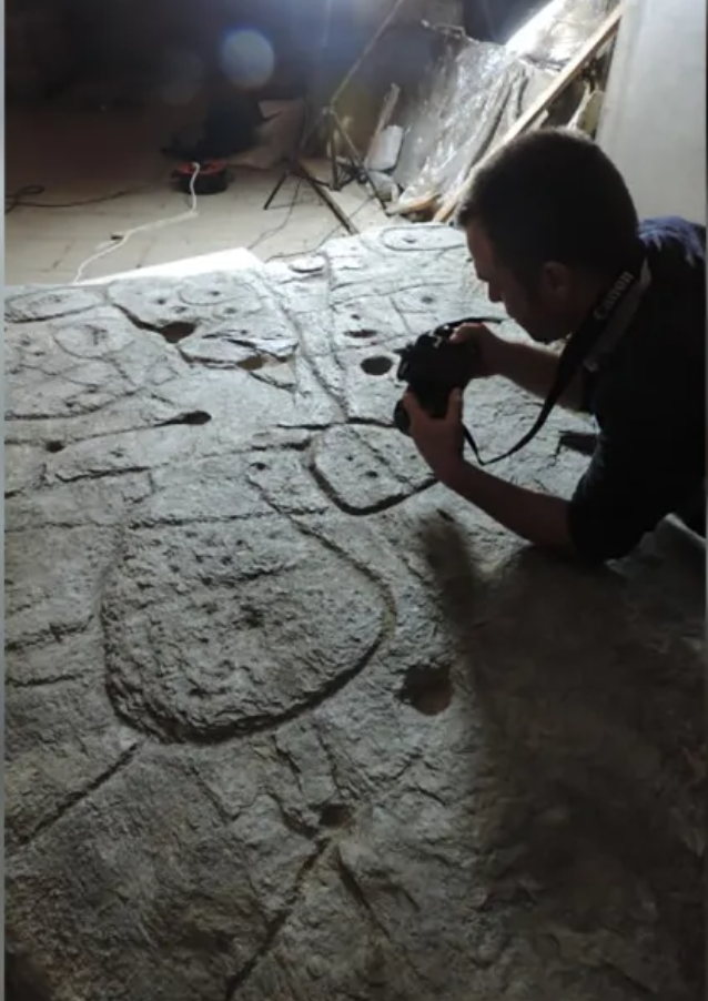
The stone "slab of Saint-Belec" was discovered in 1900 on the site of a prehistoric burial ground in Finistère as part of a grave lining. It lay in the cellars of the chateau for many decades before being rediscovered in 2014. Experts were unsure of its significance for a long time, until in 2021 it was declared the oldest map of Europe and since then scientists have been trying to decipher its symbols. Now they have found more fragments with new symbols.
The map on the stone tablet marks an area of roughly 30 by 21 kilometres. Clement Nicolas of the CNRS wants to study it all. According to him, the research may take at least fifteen years and there is probably a huge number of discoveries and adventures ahead. Nicolas and Pailler were part of the team that rediscovered the slab in 2014.
"Using a map in an effort to discover archaeological sites is a great approach. We never (normally) work this way," said Yvan Pailler, a professor at the University of West Brittany. Prehistoric sites are often uncovered by sophisticated radar equipment, aerial photography or accidentally when digging house foundations, etc. According to Pailler, this is a real treasure map...
Archaeologists have spent the last few weeks excavating the site of her discovery. The excavation has yielded a set of previously undiscovered fragments from the slab. "There were several engraved symbols that immediately made sense," said Pailler, who said the site was one of the largest Bronze Age burial sites in Brittany.
The lines and outcroppings showed the rivers and mountains of Roudouallec, located about 500 kilometres west of Paris. The slab is dotted with tiny depressions that scientists believe could refer to mounds, dwellings or geological deposits. Deciphering their significance could lead to a flood of new discoveries. So the researchers scanned the slab and compared it to current maps. They found a roughly 80% match.
"We're trying to put the discovery in context better to find a way to date it more accurately," said Pailler, who believes the plaque depicts a possible ancient principality. "The slab probably no longer made sense (later) and was doomed by being broken up and used as building material," Nicolas added. "We still have to identify all the geometric symbols and the legend that goes with them," he finally added.
Roman Nemec
Sources: phys.org, prehistoire.org, cnn.com

Europe's oldest map
detail with scale

The research took place on the site of a mound discovered in 1900

More parts of the stone slab have been recovered from the latest excavations - Europe's oldest map
The article is included in categories: